Tuning in to Earth’s climate
Satellites observe Earth using a range of wavelengths from the electromagnetic spectrum. Discover how we can obtain a more complete picture of Earth’s climate by sampling the electromagnetic spectrum at multiple wavelengths.
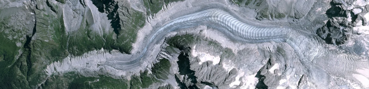
Images from Space
Discover how satellites can help us monitor our planet.
The spatial resolution
The observation of our planet using satellites depends largely on the different characteristics of their sensors. Spatial resolution, explained in this video, is one of these characteristics.
Sentinel-1: an introduction
Discover how satellites such as Copernicus Sentinel-2 offer a new perspective on Earth’s land and vegetation.
The electromagnetic spectrum
Discover the electromagnetic spectrum and how satellites can see the invisible.
Radar vision
Discover how the Copernicus Sentinel-1 mission uses its radar to provide images of the Earth’s surface in all weather conditions, day and night.
What are the differences?
In this short video, climate scientist Natalie Douglas explains the difference between weather, climate variability, and climate change. Natalie is a lecturer and researcher at the University of Surrey and collaborates on the Climate Detectives school project.
Causes and consequences
Natalie Douglas, climatologist, explains the causes and possible consequences of climate change and why a temperature difference of 0.5 degrees can be so significant.
Helping to manage water
Discover how satellites can contribute to gathering information on water resources across vast areas.
Land-use change
Satellite imagery allows us to document changes in land use with great precision. Discover how satellites provide information on land use on a global scale.
Sea-Level rise
Learn how climate change is causing sea levels to rise and how satellites have been systematically measuring sea surface height since 1992.
Sentinel-3 for oceans
Discover how the Copernicus Sentinel-3 mission is helping scientists understand the overall health of our planet.
Ocean views from space
Earth observation satellites are the guardians of our planet. Thanks to remote sensing technology and daily data collection, researchers are able to better monitor our planet’s oceans and rising sea levels from space.
Jérôme Beneviste, ESA Senior Advisor for Earth Observation Programs, explains how views of the ocean from space play a role in climate change studies and natural disaster forecasting.
Saving lives when disasters strike
Discover how satellite imagery can contribute to disaster relief and reconstruction efforts around the world.